Hikings“Hikings”
is an application which allows to record a hiking and, afterward, to
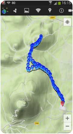
help following it on the terrain. It uses the GOOGLE maps, which can be
displayed in three modes : normal, satellite, terrain (as on the
snapshot visible on the right hand side of this page) and hybrid
(satellite plus roads shown on it).
The hiking can be recorded in two ways :
- either
by walking along it : samples are taken at a defined period of time
(selectable from 30s to 5 min) and the hiking constructs itself
progressively.
- or by preparing it directly on the map by clicking on the waypoints where we want to go.
Stored
hikings can be later recalled either for a simple examination or for
being walked along. In the latter case, the application will assist you
in your trip.
| 
|
In navigation mode, the application allows to :
- show the way to follow to reach the next stage.
- once
the stage is reached, the application automatically points toward the
next stage. Notification can be configured to warn you.
- to display several parameters related to the hiking (distance until next stage, until the end of the hiking...).
- to
display the altitude profile of the hiking. The current stage is shown
in red to facilitate the estimation of what remains to walk.
|
| 
|
| Copyright © 2015 - VolcansDev63 |
 |